Any sudden and rapid down slope movement of bedrock, regolith or a mixture of these two as a result of pull of gravity is commonly known as landslide (Crozier, 1986).
The constant pull of gravity makes all hill-slopes and high mountains susceptible to landslides. When it occurs, earth’s material is transported down-slope until a stable slope is re-established.
Landslides have negative implications on mountain biodiversity. It sometimes alters the evolutionary process of ecosystem.
It leads to loss of biodiversity in terms of habitat loss, loss of flora and fauna, causalities of animals etc. Landslides pose massive threats to floral diversity in terms of devastation of forests. It is equally a great threat to faunal diversity as the accidents of wild and domestic animals and human population are very common phenomena in mountain regions.
Studies show that landslides have increased in the Himalayas (Singh and Pandey, 1996) particularly in Nanda Devi Biosphere Reserve (NDBR). Study shows that landslides have increased in NDBR due to which landslide induced biodiversity loss has also increased.
Therefore, present paper aims at following objectives:
i. To assess the trend of landslides occurrences in the study area.
ii. To assess the linkages between the landslides and loss of biodiversity.
Present research paper is based upon primary and secondary data sources. The secondary source of information comprises of archival records, academic works, library collection and research publications. The institutions such as Wadia Institute of Himalayan Geology, Dehradun; Wildlife Institute of India, Dehradun; Forest Survey of India, Dehradun; Indian Institute of Remote Sensing, Dehradun; various departments of geology, geography etc., and researchers have been consulted for secondary data.
Apart from this, study area was visited twice in September and October, 2005 in order to collect primary data. Primary data was collected through questionnaire and interview methods (group and individual) to gather the information regarding the general perception of the villagers about landslides and its influence on biodiversity.
Villages for survey were selected on the basis of purposive random sampling. A total of 200 respondents from 10 villages were surveyed. Four villages near the core zones, four villages inside the outer boundary of buffer zone and two villages in the transition zone were surveyed.
The data was analyzed and synthesized by using various Geographical Information System (GIS), cartographic, statistical method, tabulation, diagram, graphical and other techniques. Various GIS software such as Arc View 3.2a and Erdas Imagine 8.7 were also used in present study.
Study Area:
The NDBR is located in districts of Chamoli (Garhwal), Pithoragarh and Almora (Kumaon). It is situated in the Great Himalaya in the upper watershed of the river Alaknanda, Rishi Ganga, Dhauli Ganga and Pindar River. It lies between 79°13′ E to 80°17′ E longitude and 31°04′ N to 30°06′ N latitude. For the first time, Eric Shipton and W.H. Tilman made their way to the Nanda Devi basin successfully in 1934.
An area of 182.63 sq km was then declared as Nanda Devi Sanctuary in the year 1939 with the influence of Shipton and Tilman. The sanctuary was converted into National Park in 1982 covering an area of 624.62 sq km. Further the conservation efforts were accelerated with the up gradation of National Park to Biosphere Reserve in 1988, increasing the area up to 2,236.74 sq. km.
Subsequently in 2002, the area of Biosphere Reserve was increased up to 5,860.69 sq. km including the Valley of Flowers National Park and surrounding area in it. An area of 524 sq. km was further added as transition zone, bringing NDBR to a total area of about 6384 sq. km. The area of core zones is about 712 sq. km while buffer zone covers about 5,148.57 sq. km. It surrounds the core zone on all sides.
Presently there are 47 villages in the buffer zone of the Reserve and 54 in the transition zone, while both the core zones are free from the human habitation. Of the 47 villages of the buffer zone, 34 are in the Chamoli sector of Reserve while 10 and 3 are in the Pithoragarh and Bageshwar sectors respectively.
The NDBR was one of the 14 established biosphere reserves throughout India to represent country’s vast biological and geographic diversity under the Man and Biosphere programme of UNESCO. The entire Reserve has been divided into three zones viz., the core zone, the buffer zone and the transition zone. There are two core zones i.e., Nanda Devi National Park and Valley of Flowers National Park both designated as world heritage sites.
Physiographically, NDBR is a vast glacial basin with high altitudinal variations. It consists of many snow laden lofty peaks, large and small glaciers, glacial torrents, waterfalls, alpine meadows, hillocks, colourful boulders, moraines, steep gorges and overhanging cliffs, besides the thick forest down the valley. The boundary of NDBR runs along prominent natural features.
The climate is monsoon type with an average annual precipitation of 900 mm. It varies from 700 mm to over 2,000 mm, which is restricted to short period of two months (July and August). The months of September-November are dry. Winter rain occurs occasionally in January with very low temperature. Thunderstorm with hail may occur in April-May with a short summer season. The maximum temperature ranges between 32-25°C in July, while minimum temperature goes below 0°C.
Landslides in Himalaya:
Landslides are very common in Himalaya especially during monsoon season. Himalayan landslides can be attributed to the fact that, Himalaya lies at the convergence zone of two lithospheric plates i.e., Indian Plate in the south and Eurasian Plate in the north.
Thus geologically, it is considered very active as the height of the Himalaya is still increasing. It is made up of complex geology, geomorphology and geo-hydrology. There are several big thrusts viz., Main Boundary Thrust (MBT), Main Central Thrust (MCT), Almora Thrust, Vaikrita Thrust, Krol Nappe, Chail Nappe etc., dividing Himalaya into number of fragments.
Presence of large number of faults and lineaments make the region geologically very fragile and susceptible to landslides. Little imbalance in elements of above stated shear stress factors might trigger landslides. During rainy season, additional water is added to the existing factors, which accelerate shear stress factors. Thus, condition of the bedrock become fluid and landslides take place.
Crozier (1986) suggested that landslides do not occur in isolation, there are number of factors that trigger landslides and in return landslides also influence their physical environment. As per field investigations, it was found that most of the landslides are natural and anthropogenic activities such as construction of roads and dam are triggering events.
Increasing anthropogenic activities particularly construction of roads and dams have further contributed to the process of slope failures. Introduction of road has become a prime cause of landslide occurrence in Himalayan region (Singh and Ghai, 1996). Similarly, Gongxian (1996) reported that railway tunnels were an important cause of landslides in mountains of China.
Salient Features of Himalayan Landslides:
Some salient features of Himalayan landslides are described below:
i. Landslides in Himalayan region are not of very huge scale. In Rockies and other huge mountains, there are large numbers of landslides involving hundreds to thousands of million cubic metres of rock material but numbers of huge landslides are very less in Himalaya.
ii. Repetitive landslides are significantly more in Himalaya. These are noticed particularly in highly fractured and sheared rock-mass and also in soft-hard rock alterations. In the intervening period, climatic factors become operative until sufficient weathered and disintegrated materials are brought down by heavy downpour.
iii. Though in Himalaya, summer rains start in month of June, devastating landslides mostly takes place in later part of the monsoon i.e., August and September. Probably, this is because initially the subsoil can accommodate lot of percolation. But when the subsoil becomes saturated after a few months, it cannot any more absorb water. Thus, the surface run-off increases, which causes landslides. Another factor may be that earlier rain weakens the slope forming materials while later rains remove them.
iv. It is observed in number of cases that along the river valleys when the main fissility in competent rock dips into the hills relief, fractures open up but when the same fissility dips towards the valley, fractures rarely develop. Many failures are known to occur due to slip along such fractures during construction, sometimes killing people. A large number of Himalayan landslides are of shallow depth.
v. Most of the landslides in the Himalaya are caused by anthropogenic interferences like road and dam construction.
Landslides in Nanda Devi Biosphere Reserve:
NDBR lies at the interface of glacial and non-glacial environment and peri-glacial lies between the two. So the mechanisms and types of mass wasting change according to prevailing environment. At the lower altitudes in non-glacial i.e., fluvial environment, landslides are common phenomena.
In the peri-glacial environment, gelefluction (freezing-thawing process) is most common resulting in disintegration of bedrock that forms the pattered ground, while avalanches are found at high altitude in peri-glacial and glacial environment.
Field investigations, discussion with concerned researchers working in Reserve and extensive literature survey suggests that landslides triggering events can be categorized into two groups, (1) natural factors and (2) human activities particular slope modification. (Figure 1)
Natural Driving Forces:
It includes geomorphology, geology, excessive rainfall, triggering events etc. Slope of geologically active NDBR are made up of complicated geo-structural and topographic set-up. Reserve is located north of the MCT-II, while the Vaikrita thrust i.e., MCT-I passes across the area. Presence of number of faults and lineaments like Malari-Debrugheta fault provide a very fertile ground for landslide occurrences. A total of four hot springs are reported from the Chamoli sector of the Reserve.
Presence of numbers of nick points in river courses of Alaknanda, Bhundyar Ganga, Sarashwati, Dhuali and Rishi Ganga as reported by Shah (1991), Bisht (2002) and by researcher himself during the field survey in 2005 prove in rejuvenation and fragile geology of the region.
Shah (1991) and Bisht (2002) reported about five knick points in Alaknanda River, from Satopanth Lake to Vishnuprayag indicating rejuvenation and channel sedimentation phases. The longitudinal profile of the upper reaches of Alaknanda (near Satopanth Lake) is steeper and of glacial erosion, while channel gradient is quite low in downstream of Satopanth Lake that represents glacial depositional phase.
The profile shows sudden steepness downstream of Badrinathpuri (Figure 2). The channel gradient is low at Mana-Badrinath basin and Lambagarh where Alaknanda was blocked for some time during the past. Gradient of river is steep from Lambagad up to Govind Ghat, then again slopes lose its steepness. Comparing the longitudinal profiles of Alaknanda, Bhundyar Ganga and Saraswati rivers, a distinct knick point is observed at 3400 m, which clearly represent a dynamic phase of rejuvenation in the area.
There is an occurrence of riverbed scours and plunge pool marks on highly fractured and jointed granitic rocks up to 200 m from the present riverbed in Saraswati at Mana, high channel slope of Bhundyar Ganga after 3,400 m formation of Mana-Badrinath basin. Below this altitude the deep gorge downstream of Govind Ghat are clear indicators of rejuvenation in the area.
Dhauli Ganga has most tortuous course than any other river of the region. There are three sudden falls in the river of Dhauli Ganga between the villages of Malari and Tapoban. The fall (knick point), which is about 6 miles above the village of Tapoban, is the maximum.
It falls about 150 m in the distance of 250 yards only. Two knick points observed in the river are near village of Jumma and 3 kms downstream of village of Malari. Most of the course of the river is under huge boulders. Thus the river is hardly visible most of the time. Whole course of the river can be said to be through a narrow pass with almost perpendicular cliffs on either side, several thousand feet high and wild in the extreme.
All the above stated factors implies that the region has fragile geology and experienced rejuvenation in past. It provides a fertile ground for landslides occurrence. Wherever excessive rainfall, triggering events and fertile ground for landslide occurrence are found, it results in landslides.
Human Driving Forces:
Human factors include activities like road construction, dam construction, hotel-resorts etc. These have strong bearing on the landslides. First road in Himalayan region was introduced way back in British colonial period (Singh and Ghai, 1996). But it was only after the Indo-China War of 1962 that the road construction was intensified in the Himalaya. Thereafter, Indian engineers blasted gigantic networks of road and communication facilities deep into hills of the Himalaya. In NDBR, the history of road construction goes back to 1960s. In 1964, for the first time, roads were constructed in the Reserve.
Local people reported that initially about 135 kms of roads were constructed in the region. About 50 kms of road were further added to existing network of roads in 2000. Now the road in Mana valley has been declared as national highway (Haridwar-Badrinath National Highway) due to which slopes are now in the process of being over-modified.
Thus, shear stress factors are exceeding shear strength factors and landslides are increasing. After the introduction of roads, landslides have become very frequent in the Reserve. The correlation between construction of roads and landslides is depicted in Figure 3a-c. It has a three-stage relation.
First stage, which is the pre-modified stage of natural slope, shows the steady-state condition (Figure 3 a). Then the natural slopes are modified or undercut for the construction of road and dam etc. Thus, steady-state condition is disabled (Figure 3 b). Then landslides take place so that steady-state condition is re-established (Figure 3c). Therefore, landslides can be said to be nature’s rule of equilibrium.
Built-up land has also increased in recent past due to which natural slopes have been over-modified. It has also led to deforestation in the Reserve. Thus, in many areas, condition disabled eventually increased landslides.
Strong positive correlation between occurrence of landslides and construction of roads were observed during the field investigations. Villagers reported that earlier landslides were not very common but after the introduction of road, this has become a common phenomenon. About 80 per cent of the landslides occurring now are result of road construction.
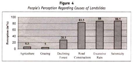
According to field survey, most of the villagers consider that road construction excessive rainfall and seismicity are main causes of landslides. About 83.5 per cent, 88 per cent, and 88.5 per cent respondents reported road construction, excessive rainfall and seismicity respectively as the most common causes of landslides occurrence in the region. Whereas declining forest cover, grazing and agricultural land expansions are other causes of landslides (Figure 4).
Agricultural land expansion, grazing and deforestation are not main causes of landslides in the region as they are in other Himalayan region, which is the result of ban on utilization of local resources. Road construction has the recent origin as the prime cause of landslide in the region.
Most of the region is the peri-glacial and glacial so ideally there should be much snow fall rather than rainfall. But local people reported that snowfall has decreased and rainfall has increased in last few decades. This can be attributed to global warning due to which rainfall regions are shifting upwards and taking place of snowfall in the Reserve. Thus, excessive rainfall in first half of monsoon saturates the bedrock and in later half removes it in the form of landslides.
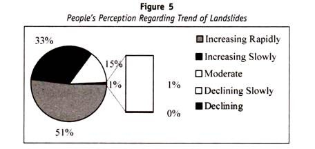
Road construction and rainfall have increased in the Reserve thus landslides have also become very frequent. Survey results show that the landslides have been increasing rapidly in region in last three decades, as about 51 per cent of the respondents reported the same, while 33 per cent reported that landslides are increasing slowly and only 16 per cent stated that trend of landslide is almost static (Figure 5).
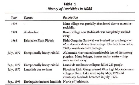
On the basis of literature and field survey, history of major landslides has been constructed. A total of 10 major landslides have been noticed. There must be some more huge landslides in the region. But these are not documented properly due to high inaccessibility of the region to the outer world.
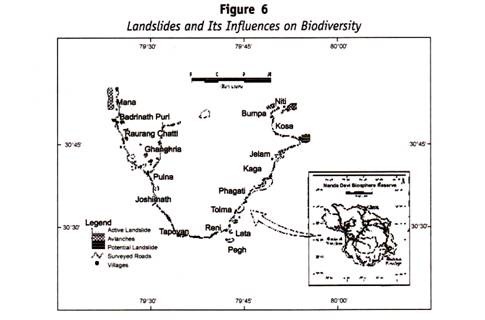
A very interesting fact can be seen (Table 1) that almost all the huge landslides are natural. About 30 landslides were noticed during field survey (Figure 6). Of the total landslides, 21 were human induced and 7 were natural. All the human induced landslides have recent origin. Thus, it can be said that human activities have aggravated the problem of landslides in recent past.
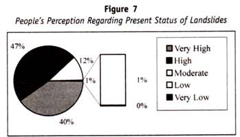
Presently, intensity of landslides occurrence is high in NDBR as about 87 per cent of the respondents indicated the same, whereas only 13 per cent indicated moderate, low and very low intensity. People who reported moderate low and very low intensity of landslides inhabit upper reaches of river valley and practice seasonal migration. During monsoon, these areas receive less rainfall.
Thus, landslides are not as common as in lower reaches of river valley. During winter when avalanches take place, they migrate to low altitude. Thus, they do not witness frequent landslides. People’s perception about present status of landslide is presented in Figure 7.
Landslides and Its Influences on Biodiversity:
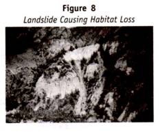
Landslides are closely related with loss of biodiversity. According to Crozier (1986) landslides are product of their environment and in return they also influence their environment. Landslides are caused by combination of natural and human factors; in return landslides devastate large areas under forests, grassland or bare land, which is the loss of habitat of number of endangered and threatened animals. Devastation of forests and grasslands are the loss of flora (Figure 8). Some time animals meet with accidents due to landslide, which is loss of fauna.
During last three decades, landslides and avalanches have increased significantly due to which biodiversity loss has also increased in the Reserve. On the basis of field investigations and discussion with concerned scientists and villagers, it was established that it is not the occurrence of landslides only that influence the biodiversity, but biodiversity itself influences the landslides pattern too.
These complex relations are listed below:
i. It was observed that there was a strong correlation between species of pine family and occurrence of landslides. Wherever the pine trees are found, the area is severely affected by landslides. This statement may be little critical because forests are considered as major determinant of landslides. It is often said that area, which is under forest cover, would be least exposed to landslides and vice versa.
But as far as pine species are concerned, on the basis of field investigations and discussion with scientists and local villagers, above stated relation can be established. Discussion with scientists suggests that the head-weight of pine tree is very high and wherever the pine is found on steep slopes, landslides are likely to take place during monsoon, if other conditions are favourable.
ii. Based on field investigations it was also found that there was strong correlation among Buransh tree, schist (geology) and landslides. It was noticed that wherever Buransh are found on schists, the area would be more prone to landslides. Field investigations show that these two species of flora and landslides have increased in the region. Thus, above stated relation can be established among them.
Two valleys viz., Mana Valley (Upper Alaknanda Valley) and Niti Valley (Dhuali Ganga catchments) have been approached for study, thus relations of landslides and biodiversity loss are initially classified in two classes i.e., case of Mana Valley and case of Niti Valley. Further, these are classified in natural and human induced landslides.
The criteria to classify landslides as natural and human induced were the degree of influence of human activities. The landslides, which are near the manmade structures such as roads, villages and dams, were called human induced landslides.
The landslides, which are far away from every human activity and in natural environment, were said to be natural landslides. About 40 landslides and about 17 avalanches sites were encountered during the field investigations, while rock fall is common phenomena along the roads and rivers.
Case of Mana Valley:
The Mana Valley consists of two major centres of religious tourism i.e., Badrinathpuri and Govind Dham. It also harbours Valley of Flowers National Park (VoFNP). Thus, the valley faces heavy inflow of tourists. The road of the valley has been declared as national highway, due to which slope modification is very intense. This has resulted in increased frequency of landslides.
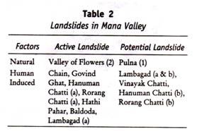
About 16 landslides were encountered in this valley, of which only 3 were found to be natural and of the 13 landslides triggered by human activities. Extensive field survey resulted in 9 of the landslides to be active and 7 to be dead which can be active any time, hence termed as Potential Landslides (Table 2).
Landslides along riverside are not numbered since it is very difficult to observe them because of deep canyons and rough terrain. But they are very common. Rock fall is also very common along roads. In almost all the cases of human induced landslides, modification of natural slope for road construction was found to be prime cause of landslide.
It is depicted from Table 2 that most of the landslides are human induced. Most of the human induced landslides are triggered by slope modification for the construction of road, except landslide near Lambagad. Landslides near Lambagad are a result of the construction of dam and tunnels.
For the construction of tunnels, the blasting technique is used beneath the mountains. It impacts in many ways like blasting results in expansion of cracks and fragile condition of regolith and bedrock, which can any time slide down the slope. Construction of tunnels results in vacuum under the mountain, which results in subsidence of tunnels if the faults, lineaments etc., are reactivated.
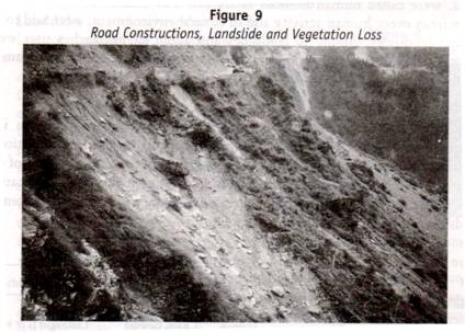
There are three landslides near Lambagad of which two are very active and one is presently dead. It can reactivate any time as one of the dead landslides activated before two years. Landslide near the Hathi Parvat is a recent one. It came into existence after the introduction of Vishnu Prayag Hydal Project. Natural slopes near the Hathi Parvat are over modified and undercut for efficient transport network for fulfilling the demands of project. Now this landslide is a perennial one. All the landslides are resulting in vegetation loss, which is also loss of habitat (Figure 9) and ultimately affects the fauna of the region.
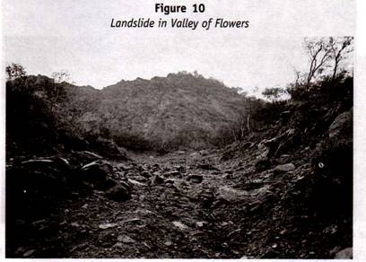
Landslides occurring due to natural steepening of slopes and reactivated geology are called natural landslides. Landslides, which were dead from long time, reactivated after Chamoli earthquake in 1999. Landslide near Pulna village and both the landslides of VoFNP are such slides (Figure 10). Natural steepening of slopes as a result of undercutting action of river along its bank is a common phenomenon in study area. Most of the river courses are severally affected by this problem.
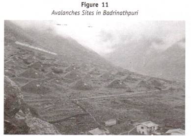
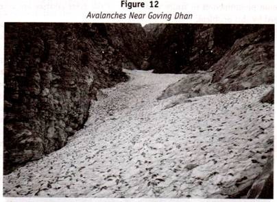
At the higher altitudes avalanches are most common. They can be seen 2,100m above means sea level. About 3 km of the area above Badrinathpuri to village of Mana, along the left the bank of river Saraswati, severely suffers from avalanches sites. About 7 avalanches sites were seen in VoFNP (5 km away of Ghanghria) and from the way to Govind Dham (4km away of Ghanghria) (figure 12). Avalanches sites were also noticed below 1 km of Ghanghria.
Case of Niti Valley:
Altogether, landslides are less common in Niti Valley than that of Mana Valley. It is due to the fact that construction activities are strictly prohibited in this valley. Road transport is not very intense. About 11 landslides were encountered in the valley of which about 6 were human accelerated and rest 5 natural.
In this valley, human induced landslides are not much because road construction is not very intense. All the six human induced landslides were active. One of the human induced landslides is very huge and intense (unnamed place), which is about 6 km ahead of Suraithota and rest 5 are big (Table 3).
This landslide is human induced and natural as well. The river of Dhuali Ganga widens its course and undercuts the base of the natural slopes. Border Road Organization (BRO) does slope modification for the construction of road. Dhauli Ganga washes away the road at least twice in a year, and BRO try to construct it. Hence this landslide is very active. This site is of about 2 km.
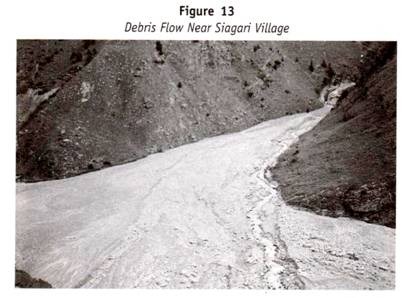
Landslide near Saigiri village is a good example of natural landslide. This site was activated for the first time in 1999 due to heavy rainfall. Earlier it was a small perennial drain and lifeline of Saigiri village. But in 1999, it activated at night and took only two hours to get its present shape (Figure 13). It devastated whole of the village and killed about 10 people. The village is now uninhabited. This landslide is active throughout the year.
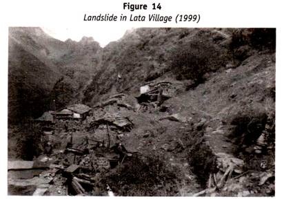
Landslide near Lata village is also a good example of natural landslides, which first time occurred after Chamoli earthquake of 1999. Local people reported that initially it was like a small volcano. Lava and hot water burst out of earth. Thereafter, it has become a rockfall zone (Figure 14).
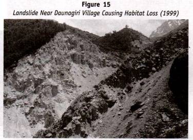
Landslide near Dronagiri village at Daunagiri Parvat is, perhaps, the result of activation of Malari-Debrugheta fault. Presences of huge sediment load in the stream make this area more prone to landslides (Figure 15). This landslide caused huge loss of forests and wildlife.
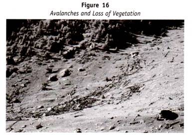
A large number of avalanche sites were also noticed in this valley. Avalanches sites are very common to observe after Lata village and 2,200 m above sea level. Avalanches sites were observed near Peng-Reni, Suraithota, Malari, Gamshali and Niti village. In almost all the cases, avalanches have become major threat to biodiversity as they cause significant loss of flora (Figure 16) and fauna. Loss of vegetation due to avalanches was very common but no evidence of loss of animals was found. However people reported that it was very common in the Reserve.
Survey results show that accidents of wild animals due to landslides are common phenomena in study area but it is very difficult to observe because the terrain of the region is very rough and undulating. Number of tourist guides, porters and local villagers reported the same.
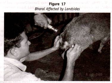
During the monsoon season, injured animals can be observed in interior regions of Himalaya. High degree of inaccessibility on the one hand and accidents of wild animals in extremely inaccessible area on the other make very difficult to observe landslides affected animals. Fortunately, I came across of one landslide victim animal i.e., Bharal during field survey, which was brought for treatment by Reserve authority (Figure 17).